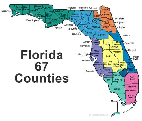
Have you ever looked at a florida county map and wondered what all those different colored areas mean? A florida county map is like a big puzzle that shows you how the state of Florida is divided into smaller pieces called counties. Think of it like cutting a big birthday cake into many slices – each slice is a county, and together they make up the whole state of Florida. Florida has 67 counties in total, which is quite a lot! Each county has its own name, its own local government, and its own special things that make it unique. When you look at a florida county map, you can see where each county begins and ends, just like looking at the borders of different rooms in your house. These maps are super helpful for many different reasons, and people use them every day for work, school, travel, and just to learn more about their state.
What Makes Florida Counties Special
Florida counties are not just random lines drawn on a map – they each have their own personality and special features. Some counties are really big, like Miami-Dade County, which has millions of people living there. Other counties are much smaller and have fewer people, like Liberty County, where you might see more cows than cars! Each county on a florida county map has its own county seat, which is like the main city where the county government works. It’s kind of like how every classroom has a teacher’s desk – the county seat is where the important county business happens. Some counties are famous for beaches and ocean fun, while others are known for farms and growing food. When you study a florida county map, you can start to see patterns about where people like to live, where the big cities are, and where you might find more nature and wild animals. This makes every county special in its own way, just like how every student in a class is special and different.
Understanding Florida’s Geographic Layout
When you look at a florida county map, you’ll notice that Florida has a very interesting shape – it looks kind of like a long finger pointing down into the ocean! The state is surrounded by water on three sides, which means lots of counties get to have beaches and coastlines. The northern part of Florida is wider and connects to other states like Georgia and Alabama. As you move south on the florida county map, the state gets skinnier and skinnier until it reaches the very bottom, where you’ll find the Florida Keys. These keys are like tiny islands connected by bridges, and they’re part of Monroe County. The shape of Florida means that some counties are really long and thin, while others are more square or round. The Atlantic Ocean is on the east side of Florida, and the Gulf of Mexico is on the west side. This special location makes Florida a peninsula, which is a fancy word for land that sticks out into the water.
The History Behind Florida’s County System
Long, long ago, before there were any counties in Florida, Native American tribes lived all over the land. They had their own ways of organizing their territories, kind of like having their own invisible county lines. When European explorers came to Florida hundreds of years ago, they started to create the first counties. The very first counties were much bigger than the ones we see on a modern florida county map. As more and more people moved to Florida, they needed to create smaller counties so that everyone could have local government closer to where they lived. It’s like when a school gets too crowded and they have to build a new school – Florida had to create new counties when areas got too crowded. Some counties were named after important people, like presidents or war heroes. Others were named after Native American words or Spanish words, since Spanish explorers were some of the first Europeans to live in Florida. Over time, the 67 counties we see today on every florida county map were created to help organize and govern all the people living in the Sunshine State.
Major Metropolitan Counties
When you examine a florida county map, you’ll quickly spot the counties that have the most people and the biggest cities. These are called metropolitan counties, and they’re like the busy downtown areas of Florida. Miami-Dade County is one of the biggest and most famous counties in Florida. It’s home to the city of Miami, which is known for its beautiful beaches, tall buildings, and lots of different cultures all mixed together. Miami-Dade County has millions of people living there, making it one of the most crowded places in the entire state. Another big county is Broward County, which is right next to Miami-Dade and includes cities like Fort Lauderdale. Orange County might sound like it’s all about oranges, but it’s actually home to Orlando, where you can find Walt Disney World and Universal Studios! Hillsborough County includes the city of Tampa, which is famous for its football team and its big port where ships come and go. These metropolitan counties on the florida county map are where you’ll find the most jobs, the most schools, and the most things to do.
Rural and Agricultural Counties
Not every county on a florida county map is filled with big cities and lots of people. Many counties are rural, which means they have more farms, forests, and open spaces than buildings and roads. These counties are super important because they grow a lot of the food that people all over Florida and even other states get to eat. Some counties specialize in growing oranges and other citrus fruits – that’s why Florida is famous for orange juice! Other rural counties focus on raising cattle, growing vegetables, or producing milk and other dairy products. When you look at a florida county map, you might notice that many of the rural counties are in the middle part of Florida, away from the coasts. Counties like Hendry, Glades, and Okeechobee are known for their agriculture and farming. These areas might not have as many people as the big city counties, but they’re just as important because they help feed everyone. Living in a rural county can be really peaceful and quiet, with lots of room to play outside and see wildlife like birds, deer, and sometimes even alligators!
Coastal Counties and Beach Communities
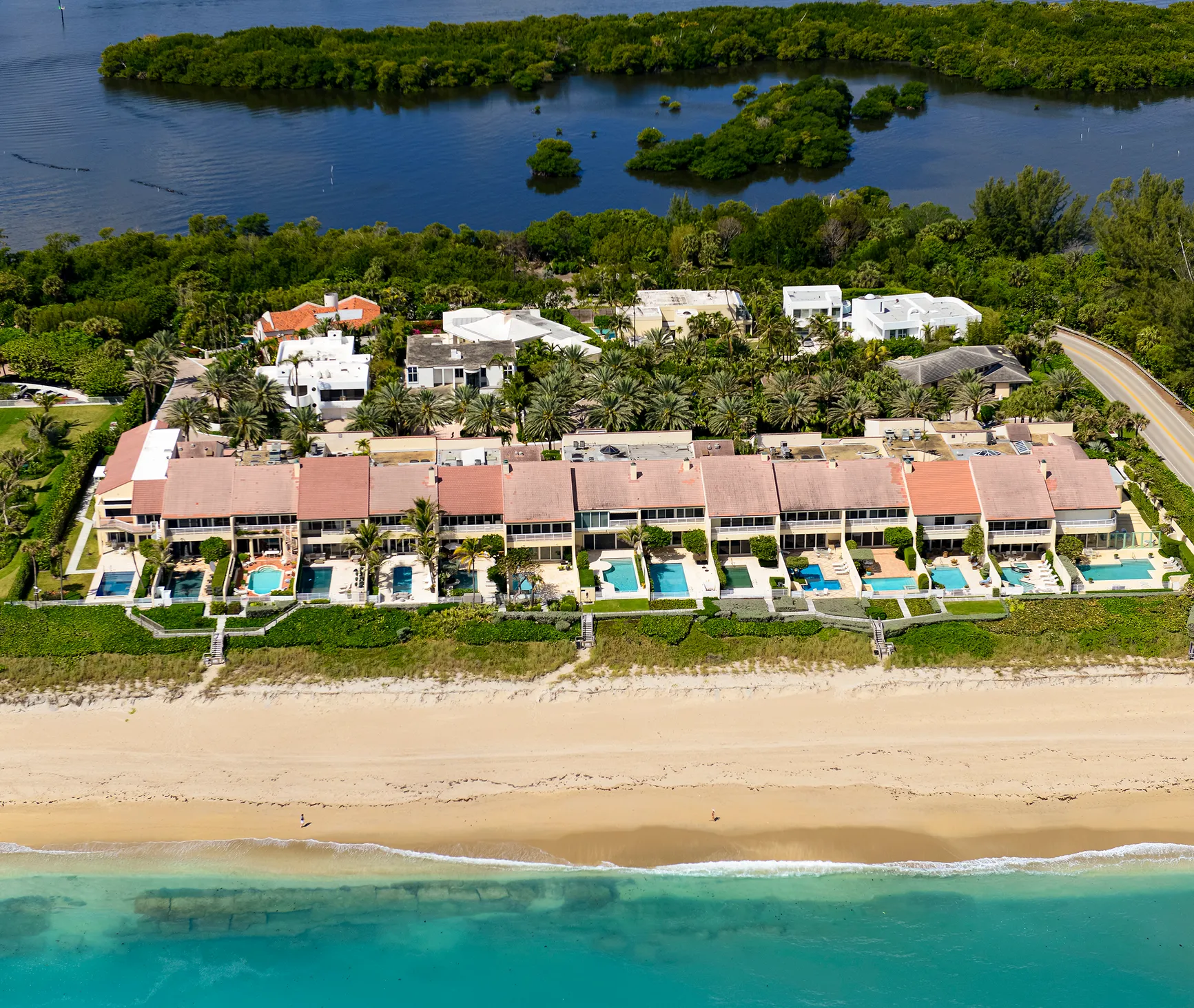
One of the most exciting things about looking at a florida county map is seeing how many counties get to touch the ocean or the Gulf of Mexico. These coastal counties are home to some of the most beautiful beaches in the whole world! Counties along the Atlantic Ocean, like Volusia County (where Daytona Beach is located), get to enjoy the sunrise over the water every morning. Counties along the Gulf of Mexico, like Pinellas County (home to St. Petersburg and Clearwater), get to watch amazing sunsets over the water every evening. Beach counties are popular places for people to visit on vacation because you can swim, build sandcastles, collect seashells, and maybe even see dolphins swimming in the ocean. Some coastal counties on the florida county map are famous for specific things – like Brevard County, which is known as the Space Coast because that’s where rockets launch into space! Living in a coastal county means you’re never too far from the beach, and the weather is usually warm and sunny most of the year.
Counties in Central Florida
The middle part of Florida, which you can easily spot on any florida county map, is called Central Florida, and it has some really interesting counties. This area is kind of like the heart of Florida, and it’s where you’ll find some of the state’s most famous attractions. Orange County is probably the most well-known county in Central Florida because it’s home to Walt Disney World, which is one of the most visited places on Earth! Millions of families come to Orange County every year to visit Mickey Mouse and go on exciting rides. Osceola County is right next to Orange County and also has parts of Disney World, plus other fun theme parks. Lake County gets its name because it has lots of beautiful lakes where people can go fishing, swimming, or boating. Polk County is famous for growing citrus fruits and has lots of rolling hills, which is unusual for Florida since most of the state is very flat. Central Florida counties are special because they’re not too far from either coast, so you can drive to the beach in about an hour from most places.
North Florida Counties
The northern part of Florida, which you can see at the top of any florida county map, is quite different from the rest of the state. These counties are closer to other states like Georgia and Alabama, so they sometimes feel more like the southern United States than tropical Florida. Duval County is one of the most important counties in North Florida because it includes Jacksonville, which is actually the largest city in Florida by land area – it’s huge! Nassau County and Baker County are more rural and have lots of forests and farmland. Leon County is special because it’s home to Tallahassee, which is the capital city of Florida. That means it’s where the governor works and where important decisions about the whole state are made. Gadsden County and Jefferson County are known for their beautiful rolling hills and historic plantations. The northern counties on the florida county map often have more trees and forests than the southern counties, and they can even get a little bit cold in the winter, which is unusual for Florida.
South Florida Counties
The bottom part of the florida county map shows South Florida, which is probably what most people think of when they imagine Florida. This area is known for being very warm, very flat, and having lots of palm trees and beautiful beaches. Miami-Dade County is the most famous county in South Florida and includes the glamorous city of Miami with its art deco buildings and international culture. Broward County includes Fort Lauderdale, which is known as the “Venice of America” because it has so many canals and waterways. Palm Beach County is where you’ll find fancy resorts and the city of West Palm Beach. As you go further south on the florida county map, you’ll reach Monroe County, which includes the Florida Keys – a chain of small islands connected by bridges. The very last key is called Key West, and it’s the southernmost point in the entire United States! South Florida counties are popular with tourists from all over the world because of the warm weather, beautiful beaches, and exciting nightlife.
How County Boundaries Were Determined
You might wonder how people decided where to draw the lines between counties on a florida county map. It wasn’t just random – there were actually good reasons for putting county boundaries where they are. Many county lines follow natural features like rivers, lakes, or mountain ridges. In Florida, since there aren’t really any mountains, county lines often follow rivers or other waterways. For example, some counties are separated by rivers that flow through the state. Other county boundaries were drawn based on how far people could travel in a day back when everyone rode horses or walked everywhere. County seats were usually placed so that people living anywhere in the county could travel there and back home in the same day. Sometimes county lines were drawn to make sure each county had about the same number of people, or to make sure each county had access to important resources like water or farmland. Political reasons also played a part – sometimes new counties were created because people in one area wanted their own local government instead of being part of a bigger county.
County Seats and Government Centers
Every single county on a florida county map has what’s called a county seat, which is the main city where the county government is located. Think of the county seat like the headquarters of the county – it’s where the most important government buildings are, including the courthouse where judges work, the county commission building where local laws are made, and often the main library and other important public buildings. Some county seats are also the biggest cities in their counties, but not always. For example, Miami is the county seat of Miami-Dade County and also the biggest city. But in some counties, the county seat might be a smaller, older town that was chosen for historical reasons. The county courthouse is usually the most important building in any county seat, and it’s often one of the oldest and most beautiful buildings in the area. Many courthouses in Florida were built in the early 1900s and have really interesting architecture. When people need to do official business like getting married, registering to vote, or paying taxes, they usually have to go to the county seat.
Population Distribution Across Counties
When you study a florida county map along with population information, you’ll discover that people in Florida don’t spread out evenly across all the counties. Some counties have millions of people packed into a relatively small area, while other counties might have only a few thousand people spread across a much larger area. Miami-Dade County has the most people of any county in Florida, with over 2.5 million residents! That’s more people than live in many entire states. Broward County and Palm Beach County also have more than a million people each. On the other end of the spectrum, Liberty County has fewer than 10,000 people living in the whole county. This uneven distribution happens because people tend to move to areas where there are more jobs, better schools, and more things to do. Coastal counties and counties with big cities attract more people, while rural counties in the interior of the state have fewer people. Understanding population distribution helps explain why some areas on the florida county map have more roads, more schools, and more stores than others.
Economic Activities by County
Different counties on the florida county map specialize in different types of economic activities, which means they focus on different ways of making money and providing jobs for their residents. Tourism is a huge industry in many Florida counties, especially the coastal ones and those with major attractions. Orange County makes billions of dollars every year from tourism because of Walt Disney World, Universal Studios, and other theme parks. Miami-Dade County’s economy is based on international trade, tourism, and finance because Miami is a major gateway between the United States and Latin America. Agricultural counties like Hendry, Glades, and Indian River specialize in growing crops like citrus fruits, vegetables, and sugar cane. Some counties focus on cattle ranching, which might surprise people who think Florida is all beaches and theme parks. Coastal counties often have fishing industries, and some have major ports where ships bring goods from other countries. Counties with universities, like Alachua County (home to the University of Florida), have economies built around education and research. Understanding the economy of each county helps explain why different areas of the florida county map developed differently.
Transportation Networks Between Counties
Getting from one county to another on the florida county map is made possible by an extensive network of roads, highways, and other transportation systems. Interstate highways are the biggest and fastest roads that connect different counties across Florida. Interstate 95 runs along the east coast of Florida, connecting counties from Nassau County in the north all the way down to Miami-Dade County in the south. Interstate 75 runs through the middle of the state, connecting counties from the Georgia border down to the Naples area. Interstate 4 is a major highway that connects Tampa (in Hillsborough County) to Orlando (in Orange County) and continues to Daytona Beach (in Volusia County). Besides highways, there are thousands of smaller roads that connect counties and allow people to travel between them easily. Some counties are also connected by bridges, especially in areas where there are lots of waterways. The Florida Keys in Monroe County are connected to the mainland by a series of bridges called the Overseas Highway. Public transportation like buses and trains also connect some counties, though Florida relies heavily on cars for transportation between counties.
Educational Institutions Across Counties
Education is important in every county shown on the florida county map, and each county has its own school district that runs the public schools in that area. Some counties also have famous colleges and universities that attract students from all over the world. Alachua County is home to the University of Florida in Gainsville, which is one of the largest and most prestigious universities in the southeastern United States. Leon County has Florida State University and Florida A&M University, both located in Tallahassee. Miami-Dade County has the University of Miami, which is known for its medical school and research programs. Orange County has the University of Central Florida, which is one of the largest universities in the country by enrollment. Many counties also have community colleges that provide affordable education and job training for local residents. The quality of schools in each county can vary, and families often consider the school system when deciding where to live. Counties with better schools often attract more families and see more population growth. Some rural counties work together to share resources and provide better educational opportunities for their students.
Natural Features and Geography
The florida county map reveals a state with incredibly diverse natural features and geography, even though Florida is generally known for being flat. Each county has its own unique landscape characteristics that make it special. Counties in the northern part of the state, like Gadsden and Leon, have rolling hills and forests that look quite different from the rest of Florida. The central counties often feature lakes, springs, and wetlands – Alachua County alone has hundreds of natural springs where crystal-clear water bubbles up from underground. Coastal counties boast miles of beautiful beaches, from the white sand beaches of the Gulf Coast to the coral reefs near the Atlantic Coast. The Everglades, which spans across several southern counties including Miami-Dade, Broward, and Collier, is a unique “river of grass” ecosystem found nowhere else on Earth. Some counties have extensive river systems, like the St. Johns River that flows through several northeastern counties. Understanding these natural features helps explain why people settled in different areas and how each county developed its own character and economy.
Climate Variations Across Counties
While Florida is known for its warm, sunny weather, there are actually interesting climate differences between counties that you can understand better by studying a florida county map. Northern counties like Nassau, Baker, and Hamilton can actually get quite cool in the winter, sometimes even experiencing frost or freezing temperatures. These counties have what’s called a humid subtropical climate, with hot summers and mild winters. As you move south on the florida county map, the climate becomes more tropical. Southern counties like Miami-Dade, Broward, and Monroe rarely see temperatures below 60 degrees, even in winter. The Florida Keys (in Monroe County) have a tropical climate that’s warm year-round. Coastal counties generally have more moderate temperatures because the ocean helps keep them from getting too hot in summer or too cold in winter. Interior counties can get hotter in summer and cooler in winter because they don’t have the ocean’s moderating effect. Rainfall patterns also vary – some counties get most of their rain during the summer thunderstorm season, while others have more evenly distributed rainfall throughout the year.
Historical Landmarks and Cultural Sites
Every county on the florida county map has its own special historical landmarks and cultural sites that tell the story of Florida’s rich and diverse past. St. Augustine, in St. Johns County, is the oldest continuously inhabited European-established settlement in the United States, founded in 1565 by Spanish explorers. The city is full of historic buildings, including the Castillo de San Marcos, a massive stone fort that protected the city for centuries. Alachua County has several important historical sites related to Native American culture and early European settlement. Many counties have preserved historic downtowns with buildings from the early 1900s, when Florida was just beginning to grow rapidly. Some counties are home to important Civil Rights landmarks, reflecting Florida’s role in the struggle for equality. Coastal counties often have historic lighthouses that guided ships safely to shore in the days before modern navigation equipment. Agricultural counties sometimes have preserved historic farmhouses and barns that show how people lived and worked in rural Florida. These historical and cultural sites help us understand how each county developed and what makes each area unique.
Wildlife and Natural Habitats
The diverse counties shown on any florida county map provide homes for an amazing variety of wildlife and natural habitats. Florida is famous for being home to both alligators and crocodiles, and you can find these impressive reptiles in many different counties across the state. The Everglades counties (Miami-Dade, Broward, and Collier) are home to countless species of birds, including beautiful pink flamingos, great blue herons, and endangered species like the Florida panther. Coastal counties provide nesting beaches for sea turtles, which come ashore to lay their eggs in the sand. Manatees, gentle marine mammals that look like underwater cows, can be found in the warm waters of many coastal counties, especially during winter months. Forest counties in northern and central Florida are home to deer, wild turkeys, and even black bears. Some counties have special protection programs for endangered species – for example, several counties work together to protect the Florida scrub jay, a blue bird found only in Florida. Many counties have established parks and nature preserves to protect important habitats and allow people to observe wildlife safely.
Water Resources and Management
Water is extremely important in Florida, and studying a florida county map reveals how water resources are distributed and managed across the state. Florida sits on top of one of the world’s most productive aquifer systems, which means there’s lots of fresh water stored underground in most counties. However, not all counties have equal access to clean, fresh water. Northern counties generally have more abundant water resources, while southern counties sometimes struggle with saltwater intrusion, where salty ocean water mixes with fresh groundwater. Many counties get their drinking water from underground wells that tap into the aquifer system. Coastal counties have to be especially careful about protecting their water supplies from saltwater contamination. Some counties share water resources through regional water management districts that coordinate conservation and distribution efforts. Lakes and rivers are also important water sources for many counties. The Kissimmee River flows through several central Florida counties, while the St. Johns River serves counties in northeastern Florida. During dry periods, counties sometimes have to implement water restrictions to conserve this precious resource.
Tourism and Recreation Opportunities
Tourism is a major economic driver for many counties visible on the florida county map, and each county offers different types of recreational opportunities for visitors and residents alike. Theme park counties like Orange and Osceola attract millions of visitors every year who come to experience Walt Disney World, Universal Studios, and other attractions. Beach counties along both coasts offer endless opportunities for swimming, surfing, fishing, and boating. Some counties specialize in ecotourism, where visitors come to observe wildlife and experience natural environments. Everglades National Park spans several counties and offers airboat tours, hiking trails, and camping opportunities. Many counties have developed extensive park systems with playgrounds, sports facilities, and nature trails. Golf is extremely popular in Florida, and nearly every county has multiple golf courses that attract both tourists and local residents. Some counties are known for specific types of recreation – for example, several counties along the Atlantic coast are famous for surfing, while Gulf coast counties are popular for fishing. State parks in various counties preserve important natural areas while providing camping, hiking, and educational programs for visitors.
Future Development and Growth Patterns
Looking at current trends and studying the florida county map, experts can predict how different counties might grow and develop in the future. Population growth in Florida continues to be strong, with about 1,000 new residents moving to the state every day. Most of this growth is concentrated in metropolitan counties like Miami-Dade, Broward, Orange, and Hillsborough, which means these areas will need to build more houses, schools, and roads to accommodate all the new people. Some previously rural counties are experiencing rapid growth as people look for more affordable places to live while still being close to major cities. Counties along the Interstate 4 corridor (connecting Tampa and Orlando) are seeing particularly rapid development. Climate change and sea-level rise may affect future development patterns, especially in low-lying coastal counties. Some experts predict that inland counties may see more growth as people move away from vulnerable coastal areas. Infrastructure development, including new highways and public transportation systems, will influence which counties grow fastest. Planning for future growth is challenging because it requires balancing economic development with environmental protection and maintaining the quality of life that makes Florida attractive to new residents.
How to Use Florida County Maps
Understanding how to read and use a florida county map is a valuable skill that can help you in many different situations. When you first look at a florida county map, start by finding counties you’re familiar with – maybe the county where you live or where you’ve visited before. Most maps use different colors or patterns to show the boundaries between counties, making it easy to see where one county ends and another begins. County names are usually printed inside each county’s boundaries, often near the county seat. Many florida county maps also show major cities, highways, and sometimes natural features like rivers and lakes. If you’re planning a trip, you can use a county map to figure out which counties you’ll drive through and what attractions or services might be available in each area. For school projects or research, county maps help you understand the geographic relationships between different areas of the state. Some maps include additional information like population numbers, county seats, or the year each county was established. Digital maps on computers and phones often allow you to zoom in for more detail or click on counties to get additional information.
Conclusion
The florida county map is much more than just lines drawn on paper – it’s a window into understanding the complex, diverse, and fascinating state of Florida. Each of the 67 counties has its own story to tell, from the bustling metropolitan areas of Miami-Dade and Orange counties to the peaceful rural landscapes of counties like Liberty and Glades. By studying florida county maps, we can learn about history, geography, economics, culture, and so much more. We can see how Native Americans first organized the land, how Spanish and other European settlers created the first counties, and how Florida grew from a frontier territory into one of America’s most important states. The county system helps organize government services, schools, and public safety in a way that makes sense for local communities. Whether you’re a student working on a school project, a family planning a vacation, a business owner considering where to locate, or just someone curious about the Sunshine State, understanding florida county maps opens up a world of knowledge and discovery. As Florida continues to grow and change, its county map will continue to be an essential tool for understanding this dynamic and exciting state.