Introduction to Tallahassee
Tallahassee, the capital city of Florida, is a vibrant and historic place filled with rich culture and interesting landmarks. Understanding its layout is key to exploring the city and fully enjoying what it has to offer. Whether you’re a local or just visiting, a map of Tallahassee, Florida, can be your best friend in navigating this charming city. In this guide, we’ll dive into the details of the city’s map, helping you get to know Tallahassee like never before.
What is a Map of Tallahassee, Florida?
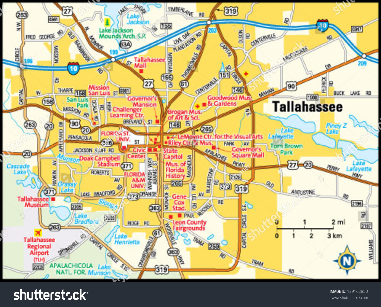
A map of Tallahassee, Florida, is a visual representation of the city that shows streets, neighborhoods, landmarks, and other important features. Maps come in various types, including road maps, topographic maps, and tourist maps. Each type serves a different purpose, so knowing which map to use can make your exploration easier and more enjoyable.Also read Exploring Manatee Hammock Campground Florida: A Comprehensive Guide
Types of Maps You Might Use
- Road Maps: These are great for driving and show major streets, highways, and intersections.
- Tourist Maps: These highlight popular attractions, restaurants, and hotels.
- Topographic Maps: Useful for understanding the terrain and natural features of the area.
Navigating the City: Key Areas on the Map
Downtown Tallahassee
Downtown Tallahassee is the heart of the city and a great place to start your exploration. This area is home to many government buildings, historical sites, and a variety of dining and shopping options. On a map, you’ll find landmarks like the Florida State Capitol and the Old Capitol, which are must-visit places.
Florida State University (FSU) Campus
The FSU campus is a significant part of Tallahassee. On a map, it’s easy to spot due to its large size and the many buildings within it. The campus is not just a place for education but also a spot for cultural events and sports. Key locations on the map include Doak Campbell Stadium and the FSU Museum of Fine Arts.
Historic Districts
Tallahassee has several historic districts, each with its own charm. The Frenchtown Historic District and the Old City Cemetery are examples of areas rich in history. On the map, these areas might be marked with their historical significance to help visitors appreciate their importance.
Using the Map for Practical Purposes
Finding Your Way Around
If you’re new to Tallahassee, a map can help you find your way around. For instance, if you’re heading to a specific event or meeting, you can use the map to locate the venue and plan your route. It’s helpful to look for major roads and landmarks that can guide you along the way.
Locating Amenities
Maps are also useful for finding amenities like gas stations, restaurants, and hotels. If you’re traveling or need a quick stop, a map of Tallahassee will show you where these services are located. Tourist maps often highlight popular spots to eat and stay, making it easier for visitors to find what they need.
Exploring Tallahassee’s Attractions
Parks and Recreation Areas
Tallahassee is home to several beautiful parks and recreational areas. On the map, you’ll see places like Cascades Park and Lake Ella. These spots are great for outdoor activities such as picnicking, walking, or enjoying a peaceful afternoon. The map will help you find the nearest park and discover what each one has to offer.
Museums and Cultural Sites
For those interested in history and culture, Tallahassee has many museums and cultural sites. The map will guide you to places like the Museum of Florida History and the Tallahassee Antique Car Museum. Knowing where these sites are on the map allows you to plan your visit and explore the city’s rich heritage.
Tips for Using a Map of Tallahassee
Familiarize Yourself with the Map Legend
Most maps include a legend that explains the symbols and colors used. This can help you understand what different markings on the map represent, whether it’s a park, a historical site, or a business. Taking a few moments to review the legend can make using the map much easier.
Plan Your Route
Before heading out, it’s a good idea to plan your route using the map. This can save you time and help you avoid getting lost. Whether you’re driving or walking, knowing your route ahead of time can make your journey more efficient.
Keep the Map Handy
Having a physical map or a digital map on your phone can be very helpful. If you’re exploring Tallahassee and need to find a specific location, having a map readily available will make the process smoother and more enjoyable.
Conclusion
A map of Tallahassee, Florida, is an invaluable tool for anyone looking to explore the city. By understanding the different types of maps and how to use them, you can navigate Tallahassee with ease and make the most of your visit. From the historic downtown area to the beautiful parks and cultural sites, a map will guide you to all the best spots in the city. So grab a map, start your adventure, and enjoy everything Tallahassee has to offer!